First backpacking trip of 2012 season

June 12, 2012

Saturday, May 26, to Sunday, May 27, 2012

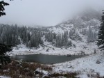
Looking east toward Red Deer Lake in the Indian Peaks Wilderness

My buddy Ian joined me for a fly fishing backpacking trip to Red Deer Lake in the Indian Peaks Wilderness to kick off my 2012 backpacking season. We were rewarded with perfect weather and pleasant temperatures.

Snowpack surrounds the sign post at the junction of the Buchannan Pass Trail and the spur to the lake.

Several feet of snow remained on the northeast-facing half-mile trail up to the lake.

At the junction of the Buchanan Pass Trail and the half-mile spur that goes west and steeply up to the lake, we found the trail was buried deeply under snow. We followed a bearing of 300 degrees and post-holed our way up to the lake. We camped on the saddle on the north side of the lake which was free of snow.

We didn’t get a nibble from the trout, but we did see a few fish rising and even a couple jumping despite what I thought must be early season torpor among the rest of the fish.

Ian brought along his new MSR Pocket Rocket, and that stove made meal prep a much more routine process than some of our past backcountry dinners. I’m sure we’ll miss his Snow Peak stove — the fondly named, but now-retired “Fireball.”

It was a short and sweet start to the season.

Looking west at a snow-covered ascent

Ian trudges up the last rise before Red Deer Lake. The lake is just beyond the crest of the rise.

Destination: Red Deer Lake, Indian Peaks Wilderness, southwest of Allenspark, Colorado

Distance hiked: about 12 miles round-trip. We hiked the Buchanan Pass Trail going in (6.7 miles) from the trailhead west of Camp Dick (rather than the trailhead at the terminus of the 4WD road), but we short-cut parts of that trail coming back out. We traveled off-trail coming back down from the lake because the north-facing trail was lost under snow sometimes four or five feet thick.

Elevation: We started at about 9,400 feet. We slept at about 10,500 feet.

Weather: sunny and clear, some strong wind gusts. The forecasts for the nearby towns (at lower elevations) were calling for gusts up to 36 mph and lows in the 30s. I don’t know the Beaufort scale that well, but I think we encountered gusts greater than 40 mph at our elevation. When I was packing for the trip I predicted a a low of 29 degrees F, based on elevation. I was a bit off.

Temperatures: low to mid 60s during the afternoon; low of 24 degrees F at about 4:00 in the morning according to my Casio Pathfinder

Pack Weight: about 19 pounds, including consumables. I carried 2 liters of water each way. On the way in, I drained my Camelbak completely. On the way out, I barely touched the water. I was definitely feeling the elevation on the way in.

My spreadsheet detailing equipment list and weights is available as a PDF on on Google docs here. (I bought a postal scale this past winter and started making spreadsheets to get serious about lowering my pack weight.)

Notes: I did a decent job estimating the overnight low temperature, but I did not anticipate how forceful the wind gusts would be. Saturday night I had an attitude-induced headache. I wish I had gone ahead and taken some ibuprofen because the headache lasted most of the night despite my drinking lots of liquids.

Photos:

The snowpack on the southwestern end of the lake was “calving” into the lake throughout the night. It looked different in the morning.
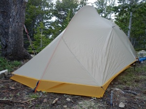
Big Agnes Fly Creek UL2

I had just bought the Big Agnes Fly Creek UL2. It was lightweight at about 2 pounds with just the rainfly, pole and ground cloth. But it did not do well in the wind, even with all 13 guylines/tiedowns in place. It did not accommodate two six-foot-tall men very well. If there had been condensation, I think the footboxes of our down sleeping bags would have been wet from contact.

Ian fishes Red Deer Lake with little success for catching trout. But the views were still worthwhile.

I took this and the other panoramas with my Samsung Galaxy Nexus phone. I really like the camera’s panorama mode.


Last backpacking trip of 2011 season

October 20, 2011

Saturday, Oct. 15, to Sunday, Oct. 16, 2011

A meadow near the Forgotten Valley backcountry shelter at Golden Gate Canyon State Park

For the second year in a row, I went to Golden Gate Canyon State Park  for my last backpacking trip of the season. Coincidentally, this trip fell on exactly the same day as last year, Oct. 15.

Rogers Pass Lake on Oct. 7, 2010

I had intended to go for my last trip the previous weekend with a couple of buddies, but the forecast that weekend called for one of Colorado’s first serious winter storms.

The first weekend of October seems to be unlucky for backpacking. In 2010, I encountered a snow storm at Roger Pass Lake on Oct. 7 and, chickening out, returned to the trail head with my buddy, Ian.

Oct. 7, 2011, wasn’t much better.

The weather near Kremmling on Oct. 7, 2011, was just as bad as backpacking exactly one year prior.

Ditching our plan to backpack to Snowmass Lake, Ian and I decided to go car camping and fly fishing near Kremmling. We thought having the safety of retreating to the car would be the most reasonable plan for a three day weekend. It didn’t matter. We encountered a low of 27 degrees that Friday night and woke up to an inch of snow. The snow kept blowing throughout the day, and, after a few cold hours of fishing without success, we bagged the rest of the trip and headed home.

Oct. 15, 2011, became my new drop-dead date for a final backpacking trip of the season. I began to eye Golden Gate as the safest bet.

Oct. 15, 2011 was a perfect day with a short hike to Forgotten Valley in pleasant fall weather

My girlfriend reasonably expressed some concerns about joining me for this overnight trip. But we caught some great fall weather, and I think we were both were glad we got in one last trip before the skiing and snowboarding season.

Golden Gate Canyon is a low-elevation park with fairly easy trails. The hikes to the backcountry camping areas are fairly short. The park offers several three-sided shelters, so we didn’t need to carry the weight of a tent. Considering these things and the comfortable trips I’ve had there the last two Octobers, I’d say this metro-Denver park is a good late-season venue for easy overnighters. It may not have the most spectacular sights, but it offers warmer weather than the Indian Peaks Wilderness or the other high-elevation areas I usually frequent.

View from the backcountry shelter at Forgotten Valley

Destination: Forgotten Valley backcountry shelter, Golden Gate Canyon State Park, Golden, Colo.

Distance hiked: about 3 miles round-trip, from Bridge Creek parking lot/Burro trail head

Elevation: This trip had very little elevation gain. The shelter where we slept was at about 8,600 feet

Weather: sunny and clear, some light breezes at times, perfect fall weather!

Temperatures: low to mid 60s during the afternoon; low of probably about 35 degrees at night (I didn’t have my watch and its thermometer, but it didn’t feel like it got below freezing.)

Pack Weight: 24 pounds + about 3 pounds for camera and its bag. I carried 2.5 liters of water, but it turned out that the small creek near the shelter was still running. I did not bring my tent, but I did bring its ground cloth to protect our inflatable sleeping pads.

Notes: I took my REI Halo 25-degree sleeping bag and my 35-degree Jacks ‘R Better Sierra Sniveller quilt. Although it seemed so warm at bedtime that I thought I didn’t need the quilt, it was nice to have it at about 4:00 in the morning when my feet became cold in the 25-degree bag. It really wasn’t necessary, but the quilt was worth its light carrying weight considering this was such a short trip.

Clothing List:

I had more clothing than needed, but I was comfortable the whole time.

green wool felt hat fedora
lightweight wool cap (only needed briefly before bed and in the morning)
lightweight waterproof bike gloves and liners (only needed liners briefly in morning)
North Face synthetic insulated mid layer (did not bring winter coat, this layer was just right)
long-sleeved Columbia Titanium SPF shirt
short-sleeved synthetic undershirt
yellow long-sleeved synthetic undershirt
hiking pants
two pairs synthetic underwear
two pairs synthetic socks, lightweight and heavy (used heavy weight socks only in the morning)
rain jacket and pants (carried, not used)
long johns (slept in these but did not need them in the morning)

Photos

This photo is not from my backpacking trip, but I had to post this great fall scene. This panorama from my Sony NEX-3 shows ranches surrounding the Williams Fork of the Colorado River near Kremmling, Colo., on Oct. 7, 2011.


Forest Lakes

September 16, 2011

Saturday, Sept. 10, to Sunday, Sept. 11, 2011

Tarp pitched uphill from the upper of the two Forest Lakes

Lacking any pressing motivation and feeling a bit fatigued, I arrived at the East Portal trailhead west of Rollinsville at the crack of … evening. I was backpacking a short distance, so it seemed fine that I didn’t start on the trail until 4:00 pm. Originally, I had intended to camp at the Arapahoe Lakes, but it seemed the Forest Service had closed the trail to those lakes.* So, I diverted to nearby Forest Lakes. (I had told folks back at home I would be at either location.) I arrived at the upper of the two Forest Lakes by 5:45 and spent about fifteen minutes scouting a good camping spot. Lots of low lying areas were wet and swarming with bugs, but I found a well-protected, previously impacted spot on the hillside on the north side of the lake.

Forest Lakes, James Peak Wilderness

I watched trout rising on the lake as I ate dinner, but I was too tired to give chase. I was in bed by 9:00 and did not get out of the bag until 8:00 the next morning. I tried fishing both of the lakes but found that they each have shallow water extending about 20 to 30 feet from the banks. The trout were easily spooked, and I had no success.

* After my trip, I called the Boulder Ranger District office and asked about the trail to Arapahoe Lakes. It turns out the existing trail was poorly designed, caused a lot of erosion and was often muddy. The Forest Service has taken down the signage for it and obliterated the trail as best they could, but bushwacking to those lakes is still possible and allowed. I asked if it would be best to hike to the upper Forest Lake and contour over to Arapahoe Lakes. The staffer agreed and said Volunteers for Outdoor Colorado may be creating a better trail in the future.

The closed trail to Arapahoe Lakes is covered with downed timber.

The old trail to Arapahoe Lakes was covered with timber at most points visible from the trail to Forest Lakes.

Destination: Forest Lakes, James Peak Wilderness west of Rollinsville, Colo.

Distance hiked: about 7 or 8 miles round-trip

Elevation: started from East Portal trail head at 9,200 feet, camped at the upper lake at about 11,000 feet

Temperatures: high 60s during the afternoon; low of 38 degrees at night

Pack Weight: 22 pounds with food and water (took tarp, bivy bag and mosquito netting rather than tent). Pack weight was 16 pounds without food and water but including Tenkara fishing rod and gear.

Notes: I took my REI Halo 25-degree sleeping bag rather than my Jacks ‘R Better Sierra Sniveller quilt. I was glad I had the full bag because it was chilly when a breeze began to blow through the tarp at about 4:00 or 5:00 in the morning.

Photos

I brought my mosquito net but saw nary a bug where I camped. The gnats were going crazy down by the water though.

I use Esbit tablets to cook when I'm trying to reduce my pack weight.

View from the upper lake

Looking down on the lower lake

Pawnee Lake

August 23, 2011

Saturday, Aug. 20, to Sunday, Aug. 21, 2011

Pawnee Lake, Indian Peaks Wilderness

My buddy Ian joined me for a backpacking and fly fishing trip to Pawnee Lake in the Indian Peaks Wilderness, but, unfortunately, our hike was not rewarded with any trout. Although Pawnee Lake enjoys a reputation on the Web as being a spot to catch cutthroats, we saw nary a fish while we were there. Usually I can at least see the trout in alpine lakes like this one, even if I can’t catch them. I wonder if this lake may not be deep enough for the trout to survive the winter freezes. That previously linked Web site says the lake is 22 feet deep. Ian and I also speculated that the Department of Fish and Wildlife might have been doing some non-native species management at Pawnee Lake that left it temporarily bereft of fish. Ian found this DOW report1 about trout species and quantities in area lakes, but Pawnee was absent from the survey. It was interesting to learn that Colorado DOW pilots stock alpine lakes2 with native cutthroat trout fingerlings.

The couloir that leads down to Pawnee Lake just west from Pawnee Pass. Rock fall obscures parts of the trail, requiring some route finding.

Also left out of trail descriptions was any mention of the scramble on the western side of the Continental Divide. Just after you start down from Pawnee Pass at 12,550 feet, you encounter a lot of rock fall that has obscured parts of the steep trail down to the lake. Descending the couloir just west of the pass can be a bit hairy with a heavy pack on. I found myself scrambling with hands and feet on the way down Saturday. On the way back up Sunday, it was more obvious where the trail was and that we had been led off-trail at least once Saturday because fallen boulders had blocked the path.

Trip Summary

The view west from Pawnee Pass, on the Continental Divide at 12,550 feet.

Destination: Pawnee Lake about 2 miles west of Pawnee Pass, Indian Peaks Wilderness west of Ward, Colo.

Distance hiked: about 11.8 miles round-trip

Elevation: started from Long Lake trail head at Brainard Lake at 10,500 feet, reached high point of 12,550 feet at Pawnee Pass, descended and camped at Pawnee Lake at just below 11,000 feet

Temperatures: probably low 80s during the afternoon; my watch read 45 degrees at 6:00 am

Pack Weight: probably 25 to 30 pounds (I did not weigh my pack, but I was carrying my normal gear plus a two-person tent.)

Notes: Double check whether the destination currently has fish before hiking all the way out there to try to catch them. It was disappointing to see no fish this time. On the up side, my Jacks ‘R Better Sierra Sniveller quilt was perfect for this trip. I slept just right: not too warm, not too cold. Even this late into August, trekking poles would be handy for Pawnee Pass. There were several snowfields remaining on the eastern side of the divide.

Photos

Looking west toward Lake Isabelle near the start of the hike.

Lake Isabelle from above.

Looking northwest toward Pawnee Lake.

Hiking southeast toward Pawnee Pass. The couloir that leds up to the pass is to the right of the rock formation in the upper left that looks like an Easter Island Rapa Nui sculpture.

Hiking southeast toward Pawnee Pass. The couloir that leds up to the pass is to the right of the rock formation in the upper left of the image that looks like an Easter Island Moai sculpture.

Sources

1Indian Peaks Wilderness Lakes FISH SURVEY AND MANAGEMENT DATA,” Benjamin Swigle, Aquatic Biologist (Fort Collins/Boulder), undated PDF file on Colorado Division of Wildlife Web site

2Stocking Native Rocky Mountain Cutthroat Trout With Planes in Colorado’s High Mountain Lakes,” Photo Gallery by Tim Romano. Uploaded on October 16, 2009, Field and Stream magazine


Crater Lakes backpacking and fishing

July 26, 2011

Friday, July 22 to Saturday, July 23, 2011

Crater Lakes, James Peak Wilderness

My friend Colin joined me for a short overnight backpacking trip to the Crater Lakes in the James Peak Wilderness west of Rollinsville, Colo. Perfect temperatures and trout jumping out of the water combined for a great weekend.

I usually bring about a dozen flies with me, and they weren’t the right ones this time. Despite the enthusiasm the fish had for the real bugs in the air, they didn’t care for the flies I had to offer. I caught only one small greenback.

Trip Summary

Putting the Tenkara rod to the test

Destination: Crater Lakes, James Peak Wilderness west of Rollinsville, Colo.

Distance hiked: about 6 miles round-trip

Elevation: started from East Portal Trailhead at 9,200 feet, camped at first couple of lakes at about 10,600 feet

Temperatures: mid-70s in the day; mid-40s at night

Pack Weight: 25 to 30 pounds (carrying whole tent, food for two, etc.)

Notes: Bring more dry flies and make sure they’re small. Like a couple of weeks ago, the fly that worked best was a Sakasa Kebari reverse hackle with size 16 hook. Floatant would have been good. My little blue Kebari wouldn’t float after that greenback had slimed it.

Photos

The trout were jumping, but I had too few dry fly patterns with me. I caught only one greenback.


Best of times, worst of times

July 13, 2011

Saturday, July 9 to Sunday, July 10, 2011

Rogers Pass Lake

After several failed attempts, I finally beat my backpacking nemesis, Rogers Pass Lake. I had tried to make that destination my final overnighter of my 2010 season in October, but I was snowed off the mountain on arrival by an unexpected early season storm. A few weeks ago my girlfriend and I post-holed our way up the mountainside in deep snowpack, but we turned around before finding the lake.

There is a ridgeline somewhere beyond those ominous clouds.

But this time I made it, only to be rewarded with a torrential downpour and rough winds as I camped at Heart Lake just above Rogers Pass Lake. There was a lot of route finding necessary on the way up to the lakes because there were still three and four feet of snow left in many areas. Thankfully, the south-facing sides of the mountains, including my campsite, were free of snow in open areas without trees.

The wind kept buffeting my tarp, and I had to reconfigure it several times.

Sunrise from open air tarp

I ended up using something similar to George Carr’s “Flying A” setup, although mine was more of a “Battened Down A.” During the worst of the storm, I worried my clothes and down bag might get wet and stay that way all night. I had visions of my tarp blowing off the mountain, posing a risk of exposure and hypothermia for me. But once I finally got inside my shelter and shed my wet gear, I was comfortable. It never got cold that night. In fact, I found myself sweating a couple of times. It turns out my bivy sack does not breath at all. There was a lot of condensation in the foot of the bivy in the morning. Fortunately, my down quilt did not become wet. That would have been bad.

Heart Lake

The morning brought several rewards. I woke up to a pink and purple sunrise and a huge jackrabbit the size of my cat just outside the open end of my tarp. He did not seem to care about my presence at all.

After an oatmeal breakfast, I tried my Tenkara rod for the first time on a backpacking trip. The first fly I tried brought no results. I could see one trout try to take it, but the hook was too large. So, I switched to a smaller, Sakasa Kebari reverse hackle with size 16 hook I had bought from Tenkara USA. On the second cast with this fly, I hooked a native cutthroat. I had landed my first fish while backpacking, and it was a rare cutthroat to make things even better!

My first backpacking catch: a cutthroat

On the way back down the mountain, I pulled out my cellphone to show my trophy to another angler. Unfortunately, I managed to drop the phone screen-first onto the sharpest rock in the trail. Now I have a pretty spider web effect on my phone.

Trip Summary

Destination: Heart Lake and Rogers Pass Lake, James Peak Wilderness west of Rollinsville, Colo.

Distance hiked: 8.4 round-trip

Elevation: started from East Portal Trailhead at 9,200 feet, camped at 11,300

Temperatures: mid-70s in the day; mid-40s at night

Pack Weight: 20 pounds

Notes: You may need to bring snowbaskets for trekking poles, waterproof gaiters and waterproof boots when hiking in the James Peak and Indian Peaks Wilderness Areas in July. I missed having the baskets for my trekking poles.

Photos

Rogers Pass Lake

Heart Lake, marmot on boulder near center-left

Tenkara rods are great lightweight choices for backpacking.

Tons of runoff at lower elevations. Be ready to get wet on the trail.

Train at East Portal of Moffat Tunnel


Wheeler Geologic Area

July 12, 2011

Friday, July 2 to Monday, July 4, 2011

The Amphitheater, Wheeler Geologic Area

Wanting to avoid the Independence Day crowds in metro Denver, my girlfriend and I headed to the San Juan Mountains to find some isolation. A coworker who is a Colorado native pointed us to Wheeler Geologic Area near the town of Creede.

Exposed volcanic rock at Wheeler is from La Garita Caldera, one of the largest eruptions ever on Earth, about 25 million years ago.

Standing above The Ampitheater at Wheeler Geologic Area

The United States just turned 235 years old. The territory that makes up Colorado has been called one of those states since 1876. I’m a Colorado transplant who has spent a couple of years enjoying this special place, but the rock I’m holding in this photo is a true native, created through a tumultuous birth an incomprehensibly long time ago. And it will still be here long after I’ve passed through.

Trip Summary

Destination: Wheeler Geologic Area, San Juan Mountains, Colo.

Distance hiked: about 17 or 20 miles round-trip. On Saturday we hiked the 6.8 or 8.4 miles (depending which Forest Service sign or Web site you believe) from the trailhead to camp outside the fence marking the border of the geologic area. Sunday we hiked the approximately three-mile loop around the geologic area. Monday it was the 6.8-8.4 miles back out.

Elevation: Trail starts at about 10,700 feet and goes up to a high of about 11,800 feet on the loop trail. Camped at about 11,000 feet.

Temperatures: high 80s in the sun; mid-40s at night

Pack Weight: 25 pounds

Notes: Four-wheel-drive vehicles, including ATVs and motocross bikes, can easily access the part of the national forest that abuts the geologic area. Camping at the end of the 4×4 road could be noisy on some occasions, but we had a quiet weekend with only one other family camped in the area.

Photos


Backpacking with Dad

July 12, 2011

Thursday, June 16 to Friday, June 17, 2011

Dad casts on the Big Thompson River outside Estes Park, Colo.

My dad came up to Colorado from sea level in June for some fishing and a bit of backpacking. This June was still too cool for great backpacking, but I think my dad was more interested in fly fishing anyways. We sampled some of the waters of the Front Range Mountains with my grandfather’s two-piece Browning western rod and my new Tenkara Iwana rod. Unfortunately, the only thing we caught on the Big Thompson River was a whiff of a dead deer on the roadside.

For backpacking I thought we should avoid the snowpack of Indian Peaks, so we headed south looking for a warmer and, more importantly, drier destination. We stopped and camped Wednesday night along the Arkansas River Headwaters Recreation Area east of Salida. The FIB-Arc whitewater race was set to start the next day, so we were lucky to get a tent pad at the Vallie Bridge campsite. It was a pleasant evening camped beside the big river. I caught — but did not land — a fish just before dusk.

Dad monitors the evening grub as the setting sun darkens the mountains north of Vallie Bridge Campground.

On the advice of a staffer at the ranger district office for the Sangre de Cristo mountains, I thought we’d try to make it to Willow Lake for our backpacking over-nighter. Pulling off the dirt road east of Crestone, we had to tack on an extra 1.5 miles to our hike in the baking afternoon sun because my little Honda could not handle the remainder of the rough road. Located well above 11,000 feet, Willow Lake proved to difficult for us to reach with our heavy packs. Willow Creek Park at 9,800 feet provided a pretty scenic turnaround point after hiking in about 3.5 miles, and we camped there for the night.

Trip Summary

Original Destination: Willow Lake, Sangre de Cristo mountains, Colo.

We camped at Willow Creek Park. Willow Lake is above the steep, well-treed wall behind me.

Destination Attained: Willow Creek Park

Distance hiked: about 7 miles round-trip

Temperatures: high 80s in the sun at low elevation; low 40s at 9,800 feet

Pack Weight: probably about 30 or 35 pounds each

Notes: Carry lighter packs! Always depart the trailhead before noon. Double check that maps have up-to-date info about roads to trailhead. The road from Crestone to the trailhead was signed as 4×4 only for the final 1.5 miles, but my National Geographic topo map showed it as being a two-wheel-drive dirt road.

Photos

Looking across the Willow Creek Park meadow toward Challenger Point and Kit Carson Mountain

Willow Creek

Challenger Point and Kit Carson Mountain


Boulder’s kind of biker bar

June 7, 2011

Peter Fonda and Sturgis riders should not watch this video.

I saw this contraption roaming the streets of downtown Boulder, Colo., last night. From what I’ve found on the Web, “My Handle Bar” just started in May 2011. Customers sit at the bar and pedal it around town. That’s right. They pedal the whole establishment around on the street. Only in Colorado would a beer drinker want to burn off those alcohol calories while drinking them.

The owners should convince Lance Armstrong to come over from Aspen and shoot a commercial with him racing this bar-bike around town while swilling Michelob Ultra.

It looked like a lot of fun, but it must feel a little disorienting to be seated and pedaling in one direction while the bar-bike moves perpendicularly to you.

Watch the “My Handle Bar” promotional video or check out their Web site.


First backpacking trip of 2011 season

June 7, 2011

Friday, June 3, 2011

I went on my first backpacking trip of the season this past Friday. Unsurprisingly, camping in the Colorado Rockies at the beginning of June was cold. Cold, but not really uncomfortable.

I wanted to test out the Jacks ‘R Better quilt I just bought. I woke up cold twice during the night: once at about 2:00 in the morning when my watch said it was about 37 degrees and again at 5:00 when it was about 34 degrees. JRB rates this Sierra Sniveller quilt at 25 to 30 degrees. I’d say it’s really a 35-degree bag for me because I tend to roll from my left side to my right and doing that sometimes untucks the quilt, letting in cold air. Fortunately, it wasn’t enough of an annoyance to keep me from falling back to sleep quickly on the bed-like luxury of my new Big Agnes pad. It’s an Insulated Air Core, and it’s a big improvement over the lightweight foam pad I used when backpacking last year and the standard Thermarest I use on car camping trips. The two and half inches of padding created by the Big Agnes make all the difference.

looking east along a valley in Roosevelt Forest near Lost LakeThe trip wasn’t much of workout or an opportunity to see the sights, but it did a good job of letting me work out the kinks in the new sleep system before my dad comes out for a backpacking and flyfishing trip in a couple weeks. I still need to replace the cheap, emergency bivy sack with something that doesn’t tear easily.

Trip summary

Original destination: Heart Lake at about 11,000 feet elevation, Indian Peaks Wilderness, west of Rollinsville, Colorado. The Boulder Ranger District office advised me that the Indian Peaks Wilderness was way above it’s normal level of snowpack for this time of year.

Destination after calling the Boulder Ranger District: much lower! — On the ranger’s advice I decided to camp in a valley along the Lost Lake/ Devil’s Thumb trail slightly above 9,000 feet, Roosevelt National Forest, west of Nederland, Colo.

Distance hiked: maybe 2 miles roundtrip, if I’m being generous.

Elevation gain: 600 feet (started at about 9000 feet, turned around at about 9600)

Camping elevation: ~9100 feet, ground was dry (snowpack of 3-4 feet was present at about 9600 feet and above)

Temperature range: mid 60’s during day, mid 30’s at night

Trip photos

This footbridge on the way to Lost Lake was still covered in a couple of feet of snow

This footbridge on the way to Lost Lake was still covered in a couple of feet of snow.

Here next to the footbridge is where I eventually turned around before heading down to find a dry campsite. The Lost Lake Trail and Devils Thumb Bypass Trail split here at about 9600 feet. I post-holed up to my calves for a while on the bypass trail as I looked for a suitably dry campsite. It wasn't happening.

For my shelter, I've switched to using a lightweight sil nylon tarp from Equinox, usually supported by my trekking poles or trees. I put my sleeping pad and quilt or bag inside a emergency bivy sack which acts as a good vapor barrier from the ground.

Sunrise. The temp shot up quickly from the 30s to the 40s after that.

This Casio Pathfinder watch is another new piece of gear. I got it for $100 from the REI Outlet. Its altimeter, barometer and thermometer features work fairly well. I don't recall if the measurement of 9100 feet in this picture was accurate, but, when the weather is stable and I've kept the watch calibrated, the altimeter has been spot on for me for the couple months I've owned it. I've had that Photon Micro Light in the top right for about a year. It's great, but I do wonder when the battery will die.

Clothing List:

green wool felt hat

mid-weight wool watch cap

lightweight waterproof bike gloves

Arc Teryx soft shell

North Face synthetic insulated mid layer

long-sleeved Columbia Titanium SPF shirt

short-sleeved synthetic undershirt

hiking pants

one pair synthetic underwear

two pairs socks (definitely needed both pairs even though this was just an over-nighter; first pair and shoes were both very damp from post-holing in snow at 9600 feet)

rain pants (carried, not used)

no rain jacket other than softshell

no long johns (other than a couple minutes hopping around and running in place when I got out of bed, I really did not miss them either)